The real show came during the day. The Storm Prediction Center put out a Moderate Risk over a large portion of the Northeast, but we were left on the northwest edge of it. The primary threats appeared to be hail and damaging winds, as the speed shear was pretty decent but there wasn't much directional shear. The CAPE quickly rose to over 2000 j/kg by late morning, and it didn't take long for towering cumulus to pop up all over NY state. Anticipation was in the air as students and professors in the Atmospheric Science department were found to be frequently looking outside the windows and excitedly discussing the situation with their colleagues.
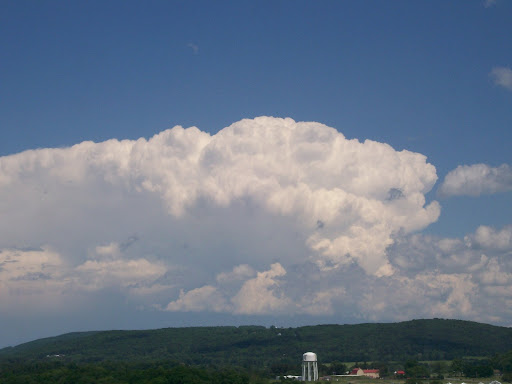
At around 1:30pm local time, a severe-warned cell passed just to the north of Ithaca. Dean and I went up onto the roof of Bradfield (11-floor tall building), along with a few other students and one of our professors to watch this storm and all of the other convective towers around us. This storm would later display a classic "a-bomb" style appearance as it moved well to the east of us. It one of the most gorgeous thunderstorms I've ever seen from a distance.
 Our direct hit of the day came a couple hours later. A severe-warned cell to the SW of us looked like it was going to miss us to the south, but a new cell quickly intensified just as it passed over parts of central and southern Ithaca. We got some pretty heavy rainfall up at Bradfield, but no hail. The lightning show was pretty exciting, and I was able to get a couple of cloud-ground strikes in the video I took.
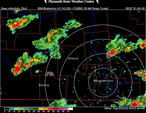
An interesting aspect of today's event was the role the lake breeze played in convective development. On visible satellite imagery, a lake breeze front was observed running along the south shore of Lake Ontario, drifting southward throughout the day. This lake breeze front served as a focus for many of the severe thunderstorms, as evidenced by the cluster of severe hail reports south of Lake Ontario. It'll be interesting to see whether this phenomenon repeats itself in any future setups.
-Leon

No comments:
Post a Comment