This evening turned out to be eventful as we've seen some of the best thunderstorm action since the June fun fest ended. Leon, Shianne, and myself were having an awesome dine-out at Maxie's restaurant. Shianne was impressively downing a big piece of chicken, Leon was predictably cleaning up on a New Orleans style catfish plate, and I was unceremoniously and unmethodically picking my way through pork ribs and pulled pork. All the while, we noticed the sky darken out the window to the north. A healthy rumble of thunder was all it took for L and S to leave their seats to investigate. Very soon, the thunder and lightning became more frequent and the rain poured down. Then, if only for a few golden minutes, the storm took things up to another notch over downtown Ithaca. The pouring rain became nearly a deluge, some moderately strong wind gusts spread out from underneath the storm, and a few strokes of lightning were quite closeby. One strike was so close--probably less than 1000 ft. away--that Leon could not restrain himself and let out a "WoooOOOOooo!!!" that was audible throughout the restaurant.
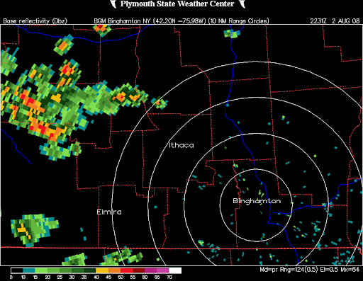
This storm, which was a multicell cluster, tracked from the northwest to southeast, and developed to its maximum intensity as it passed through Ithaca. Synoptically, we were under a pretty potent (for summer) closed upper low which made for some very impressive lapse rates from 500mb to 300mb. At the surface, we warmed into the mid 70s today with dewpoints getting into the lower 60s. With CAPE getting into the low 1000s, minimal CIN, and a surface front in the vicinity, scattered showers and storms developed accross central NY, none reaching severe limits.
As a follow up to the previous entry, last night we again observed lightning from distant storms... this time, we were able to see flashes low on the horizon from storms over the east end of Lake Ontario, about 80 miles away!
be good out there,
Dean