02 August 2008

Downtown Fun

This evening turned out to be eventful as we've seen some of the best thunderstorm action since the June fun fest ended. Leon, Shianne, and myself were having an awesome dine-out at Maxie's restaurant. Shianne was impressively downing a big piece of chicken, Leon was predictably cleaning up on a New Orleans style catfish plate, and I was unceremoniously and unmethodically picking my way through pork ribs and pulled pork. All the while, we noticed the sky darken out the window to the north. A healthy rumble of thunder was all it took for L and S to leave their seats to investigate. Very soon, the thunder and lightning became more frequent and the rain poured down. Then, if only for a few golden minutes, the storm took things up to another notch over downtown Ithaca. The pouring rain became nearly a deluge, some moderately strong wind gusts spread out from underneath the storm, and a few strokes of lightning were quite closeby. One strike was so close--probably less than 1000 ft. away--that Leon could not restrain himself and let out a "WoooOOOOooo!!!" that was audible throughout the restaurant.

This storm, which was a multicell cluster, tracked from the northwest to southeast, and developed to its maximum intensity as it passed through Ithaca. Synoptically, we were under a pretty potent (for summer) closed upper low which made for some very impressive lapse rates from 500mb to 300mb. At the surface, we warmed into the mid 70s today with dewpoints getting into the lower 60s. With CAPE getting into the low 1000s, minimal CIN, and a surface front in the vicinity, scattered showers and storms developed accross central NY, none reaching severe limits.


As a follow up to the previous entry, last night we again observed lightning from distant storms... this time, we were able to see flashes low on the horizon from storms over the east end of Lake Ontario, about 80 miles away!

be good out there,
Dean

27 July 2008

Nocturnal lightning show

Yesterday was a noteworthy day, as we received a very impressive nighttime lightning display. During the day, instability reached a maximum of around 1500 J/kg of CAPE, and an LI of around -6C. Shortly before 4pm, a thunderstorm fired up a few miles to the east of Ithaca, producing a few lightning strikes and rumbles of thunder.

The real show was to begin after sunset. I had engaged my friend in a debate about affirmative action, and I offered to show her the CNN program "Black in America", which happened to be on TV at the time. Being that my lightning detector is ALWAYS on, I noticed a few flashes outside the window out of the corner of my eye, and I jumped off the couch and did a radar check on the computer a few feet away. To my surprise, there were thunderstorms galore to the north of us, and so my friend and I went out into the middle of Jessup field to watch the lightning, while continuing our debate on affirmative action (how nerdy, I know). The lightning was quite frequent, with flashes coming every couple of seconds. Due to the abundance of low-cloud debris between us and the thunderstorms, the flashes seemed to light up a huge portion of the night sky, due to the reflective nature of those clouds.

Dean joined us a long while afterwards, apparently oblivious to the whereabouts of his two friends who mysteriously disappeared. As the storms got more the 40 miles away, we began to notice that we could see the flashes from directly above us, being reflected off of the low clouds between us and the storms. Given my lack of personal experience with thunderstorms, I had never noticed this phenomenon before, and it was really awesome!

There was a 2-inch hail report in the town of Waterville, NY...very impressive!

-Leon

23 June 2008

Nailed yet again!!!

Yes, ANOTHER direct hit!!! An upper trough approaching from our west provided the lift necessary to generate thunderstorms in an environment of around 1000 j/kg of CAPE and lifted indices at around -4C. There was abundant daytime heating, with surface temperatures rising into the upper 70s and dewpoints in the upper 50s. The shear wasn't too impressive, from a directional standpoint as well as speed, but nevertheless we ended up getting arguably our best storm this summer so far.

A storm initially passed about 8-9 miles to our south and southeast as Dean and I were eating at Appel. This storm was responsible for a few rumbles of thunder that we heard. The skies off to our west looked rather dark and ominous as well, and we saw a couple lightning strikes, so we knew what to expect. Right as we got back to our house, I observed a rapidly developing storm about 4 miles south of us. It was characterized by a very dark, turbulent-looking base that looked somewhat disc-shaped. This storm quickly evolved into a beast that Dean took an excellent panorama of:


Dean stayed outside under the bus shelter, while I oscillated between going inside the house and standing out on the porch. The aforementioned cell passed a few miles east of our location, while another cell blew up southwest of Ithaca and passed just south of us. Our location did experience some heavy rain, although we missed the core of the storms. However, the lightning show was fantastic, with quite a few close CG strikes and deafening rumbles of thunder. I caught this nice CG strike from my porch: click for clip ~1.9 MB


Looking ahead over the next week, it looks like we'll have numerous opportunities to build upon what has been a phenomenal summer so far!

-Leon

20 June 2008

Best of the Year (so far)

Today as I sat behind my computer up in Bradfield, I really didn't know what was going on outside. Leon was checking the radar as always, but I hadn't seen any radar, satellite, maps, soundings, read any discussions, or even looked out the window to observe the clouds. OK, I knew that we've been under a pretty stagnant upper level trough since earlier in the week, but that's about it.

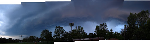
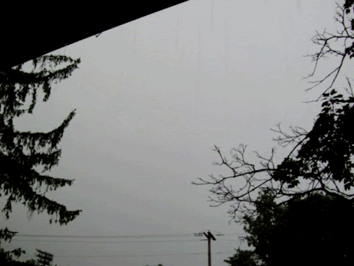
Fast forward to 5pm today. Leon makes a rather smooth exit from BF (he had seen the radar and wanted to make it home dry!), without so much as hinting at me that there's any weather of interest going on. 10 minutes later, standing outside Emerson Hall, and seeing a moderate rain falling, I decided to park and wait it out. That's when the first thunderstorm moved in from the west. This one had a pretty steady moderate-heavy rain due to a training of individual cells developing on the backside. As this storm finally pushed east and the rain started letting up, I walked through the Ag quad just to see the most amazing of sights. Literally right overhead on campus, a new storm was taking shape. Strong vertical motions were visible near the cloud bases, and there were several cloud to ground lightning strikes that were within a mile--too close for comfort. I decided to make a dash for it--to try to run home to north campus while I had the chance. As I ran past MVR, the rain picked up. It became heavy as I hustled across the footbridge and then, all of a sudden, became torrential. There was shelter in the form of an overhang at the Noyes Lodge building. For the next 5 minutes or so, there was torrential rain mixed with dime sized hail. Once I got home, the heavy rain picked up again as yet another cell tracked over us from the west.

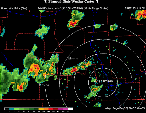
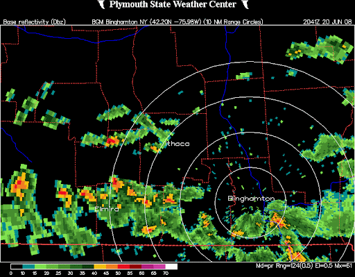
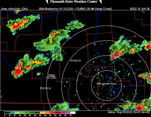
For once, it seems, we were the lucky ones. From looking at the radar, it seems as though what caused the strong t-storm to develop over us was a quick convergence of the line of cells that hit us first and some thunderstorms moving northeastward out of Chemung county. It is remarkable how fast this all happened--going frame-by-frame on the radar, we went from having ~25 dBz to 55-60 dBz in 4 minutes, and the intensity gradient on the backside was very sharp.

Sorry for the long post. Anyway, I hope you have a good weekend out there, whether you're reading from Fresno, Ithaca, or even Norman. We might check out the Ithaca Festival this weekend--there's gonna be music, hippies, and maybe even some crystal healing if we're lucky.

-Dean

18 June 2008

June 16th: Two direct hits !!!

The first direct hit came at around 1:30am. I had gone to bed about an hour earlier, but I was awoken by rumbles of thunder and flashes of lightning out my window. The storm wasn't very impressive on radar, but it still delivered a pretty decent lightning display. I stayed up for over an hour watching/listening to the storm from my bed, and predictably I was extremely tired the next morning.

The real show came during the day. The Storm Prediction Center put out a Moderate Risk over a large portion of the Northeast, but we were left on the northwest edge of it. The primary threats appeared to be hail and damaging winds, as the speed shear was pretty decent but there wasn't much directional shear. The CAPE quickly rose to over 2000 j/kg by late morning, and it didn't take long for towering cumulus to pop up all over NY state. Anticipation was in the air as students and professors in the Atmospheric Science department were found to be frequently looking outside the windows and excitedly discussing the situation with their colleagues.

At around 1:30pm local time, a severe-warned cell passed just to the north of Ithaca. Dean and I went up onto the roof of Bradfield (11-floor tall building), along with a few other students and one of our professors to watch this storm and all of the other convective towers around us. This storm would later display a classic "a-bomb" style appearance as it moved well to the east of us. It one of the most gorgeous thunderstorms I've ever seen from a distance.


Our direct hit of the day came a couple hours later. A severe-warned cell to the SW of us looked like it was going to miss us to the south, but a new cell quickly intensified just as it passed over parts of central and southern Ithaca. We got some pretty heavy rainfall up at Bradfield, but no hail. The lightning show was pretty exciting, and I was able to get a couple of cloud-ground strikes in the video I took.


An interesting aspect of today's event was the role the lake breeze played in convective development. On visible satellite imagery, a lake breeze front was observed running along the south shore of Lake Ontario, drifting southward throughout the day. This lake breeze front served as a focus for many of the severe thunderstorms, as evidenced by the cluster of severe hail reports south of Lake Ontario. It'll be interesting to see whether this phenomenon repeats itself in any future setups.

-Leon

10 June 2008

A Little Bit of Action

Last night, we knew there was a potential for severe wx today. The setup didn't look too eye popping, but in general, we knew that with decent amounts of CAPE and shear ahead of an aproaching cold front, there was a distinct risk. Not yet having internet access in our co-op room, we weren't looking at this situation too closely. This morning, I got on the downstairs computer (which has working internet) to find, shockingly, that the SPC had upgraded our risk today from slight to moderate! A couple hours later when we got into Bradfield, we were again surprised as we were put under a Tornado Watch along with northern NY and western New England. I questioned the logic of this move since our wind shear was looking mainly unidirectional, not favoring supercells.

What panned out today was, for us, a little disappointing. The SPC was correct in its outlining of the moderate risk zone today, as there were numerous reports of hail and wind damage in the storms. However, we found ourselves just a bit too far to the west of the main action. There were two main lines of storms that formed today. The first line was the one that did the most damage, feeding on the clear skies and best CAPEs off to our east. One cell popped up just about 10 miles to our northwest around noon, tracking east-northeast. It was responsible for some downed trees just to the east in Cortland county and nickel sized hail further on in Chenango county. We could see the leading edge of the outflow from Bradfield:


The second round of storms came as a line associated with the front this evening around 6. These storms weren't as potent as in the first line, but at least this time we took a direct hit... but still missed out on the brunt as it passed to our south. The good part of it all is that we can finally breathe again inside our sauna-like co-op house.

-Dean

09 June 2008

Back in Ithaca

Yes folks, we are back in Ithaca, NY after a long 3-week absence. I took an overnight flight Saturday night across the country from LA to Philly, and what a flight it was! We flew south of a rather large thunderstorm cluster, or a mesoscale convective system (MCS), that was located over portions of Nebraska and Iowa. Being such a weather geek, I always book a window seat, and this time I was tremendously fortunate to have been on the left side of the plane. The storms were in a line that spanned several hundred miles west to east, so there was continuous lightning throughout my field of vision for around an hour or more. Growing up in California, I've never really had the opportunity to witness lightning shows of such intensity, so it was easily the best lightning I've seen in my entire life.

The best part of the show was that I witnessed a sprite. It occurred very quickly, literally in a blink of an eye, above the thunderstorms. It appeared to be whitish in color, although this probably was more due to how quickly it appeared. I wasn't absolutely certain at first, but after the hour of observing lightning, I never had that visual phenomenon appear again, so I am now quite certain that it was indeed a sprite. Yep, my first sprite ever!!!


Sunday, June 8th...we had several thunderstorms brush by the Ithaca area. With temperatures rising into the mid 80's and dewpoints in the low 70's, the atmosphere was well juiced-up, although the vertical wind shear was lacking. Luckily none of these thunderstorms made a direct hit on me when I was walking the 3.5 miles from the airport to my house (hey, I ain't gonna be ripped off by no $15+ taxi ride).

-Leon

30 April 2008

First Hit of the Season!!!


As Alumni Weekend BBQ festivities were wrapping up, we got a bit of a surprise (to some, but not Leon of course). On a day where the CAPE was supposedly only around 500J/kg, clear skies allowed for much stronger than anticipated surface heating, and with the help of an advancing cold front to the west, a line of thunderstorms developed. The line, which was NNE-SSW oriented, stretched from east of Lake Ontario through central NY and down through PA, where some of the storms were almost severe. The portion of the line that came through Ithaca was interesting to watch--a gust front running parallel and out ahead of the line by 5-10 miles created an ominous low shelf-ish cloud deck. We got out to Libe Slope just as the heaviest stuff came through, but unfortunately it was weakening and there wasn't too much in the way of downpours or even lightning to check out. But, a hit is a hit, and this one's number one.

-Dean

Unlimited Free Image and File Hosting at MediaFire

Tally update:
Total count: 2
Direct hits: 1